LOCATION
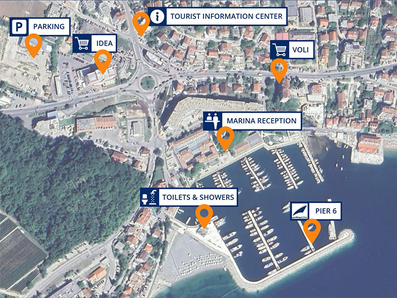
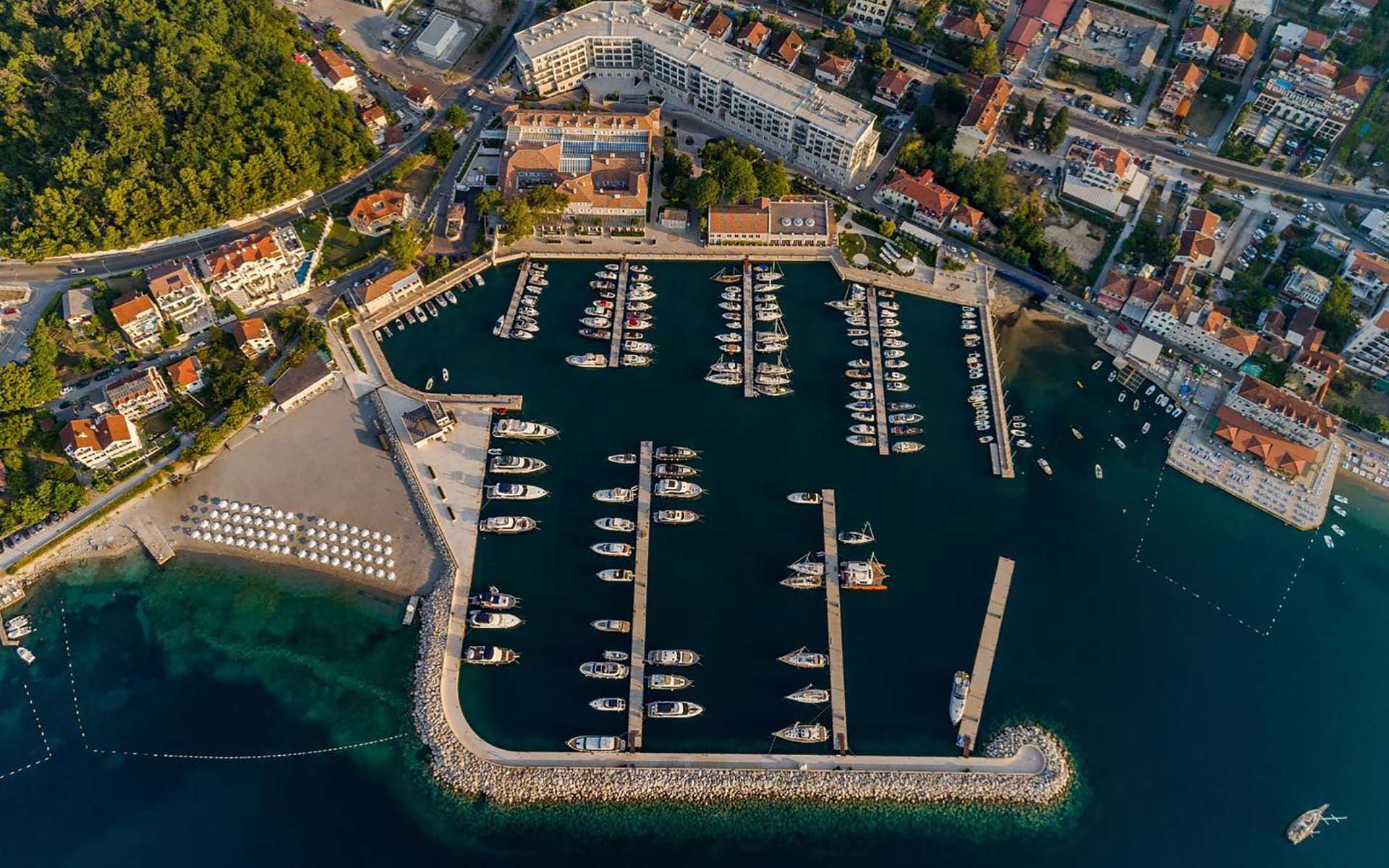
Marina Lazure
Address: Herceg Novi, Braće Pedišića 10, Montenegro 85340
Yachts's location: PIER # 6
Base manager: Nikola Milentijević
+381 63 7769 525
office@yachtingadria.com

Marina Lazure
Address: Herceg Novi, Braće Pedišića 10, Montenegro 85340
Yachts's location: PIER # 6
Base manager: Nikola Milentijević
+381 63 7769 525
office@yachtingadria.com
Supermarket Idea, City Market, Bakery, Baguetteria, Pharmacy
Wine o' Clock, Augusto Terrace at marina Lazure
Budget restaurants near marina: Monte Carlo (meat, fish), Barbi (pizzeria), Leut (meat, fish)
Feral - very good restaruant in Herceg Novi's old town, reachable 5 minutes by taxi from marina or a 20 minutes seaside walk
Free and secured car parking for our guests across from Eko gas station
At the end of your sailing trip, please use the gas station at Portonovi or Portomontenegro in Tivat.
For detailed information about marinas and anchorages we recommend installing application www.navily.com
Lazure: VHF 87, www.lazure.me
Services: Water, Electricity, Toilets & Showers, Wi Fi, Restaurants, Bars
Portonovi: VHF 74, portonovi.com/me/marina
Services: Water, Electricity, Toilets & Showers, Wi Fi, Gas station, Restaurants, Bars, Shops
Portonovi petrol station: VHF 15
Portomontenegro: VHF 71, www.portomontenegro.com/marina
Services: Water, Electricity, Toilets & Showers, Wi Fi, Gas station, Restaurants, Bars, Shops
Lustica Bay: VHF 68, lusticabay.com/lustica-bay-marina
Services: Water, Electricity, Toilets & Showers, Wi Fi, Restaurants, Bars, Shops
Kotor: VHF 17, maps.app.goo.gl
Services: Water, Electricity; Restaurants, Bars, Shops in the old town
Dukley Budva: VHF 8, www.dukleymarina.com
Services: Water, Electricity, Toilets & Showers, Wi Fi, Gas station; Restaurants, Bars, Shops in the old town
Bar: VHF 09, marina-bar.me
Services: Water, Electricity, Toilets & Showers, Wi Fi, Gas station; Restaurants, Bars, Shops in the town
Žanjic 42° 23.93' N, 18° 34.70' E and Mirišta 42° 23.72' N, 18° 34.57' E
Both anchorages have some buoys for yachts, but we recommend Mirišta because it is better protected from the waves.
Restaurant Mirišta has its own big, strong buoy, and you can spend the night here if you dine at the restaurant. Restaurant staff will help you moor the yacht and make a transfer to the restaurant.
A pier for yachts can be found at a restaurant Ribarsko Selo, phone number +382 69 101 803.
Island Stradioti 42° 24.47' N, 18° 41.68' E
The seabed is mud, and the anchor holds very good. You can spend the night at anchor.
There is a nice restaurant across the island called Vino Santo, which has a little pier for yachts, phone number +382 67 655 888.
Morinj Bay 42° 29.43' N, 18° 39.27' E
There are some red and yellow buoys which belong to a restaurant, Ćatovića mlini, which is known as one of the best restaurants on the coast nested in very scenic surroundings.
The restaurant staff can arrange a dinghy transfer from your yacht, phone number +382 32 373 030.
A small pier for yachts can be found at a restaurant Konoba Ribar, phone number +382 69 488 566.
Dobra Luka 42° 22.15' N, 18° 37.98' E
The seabed is a mix of sand, weed, but also rocks. It's not hard to spot them because the water is very clear.
A very nice place for swimming, and there is absolutely no development there.
Another nice anchorage is at position 42° 22.58' N, 18° 39.20' E, the name is Velja Spilja Beach or Kamenolom (stone-pit).
Bigova 42° 21.23' N, 18° 42.27' E
The owners of the restaurant Grispolis provide buoys for their guests. They will send a tender to pick you up and drop you back to your yacht after you have lunch or dinner.
If you sail during the high season, we recommend making a reservation in advance. Phone number +382 69 357 657.
Trsteno 42° 16.75' N, 18° 47.30' E
The seabed is sandy and good holding.
Jaz 42° 16.77' N, 18° 48.10' E
Pećin Cove 42° 9.78' N, 18° 59.30' E
Maljevik 42° 8.37' N, 19° 1.35' E
There is a reef and underwater rocks, possible gusts of NW wind in the afternoon.
Valdanos 41° 57.13' N, 19° 9.80' E
The bottom is gravelly, and the anchor does not hold well.
Ulcinj, 41° 55.33' N, 19° 12.23' E
The jetty is high, and there are always waves, so it is better to anchor.

works 7 am to 8 pm. Health care for foreigners are concerned by the international laws. Before traveling to Montenegro please check your Health insurance coverage.
ATM machines works around the clock. Payment in shops and restaurants could be done via credit or debit cards.
Herceg Novi
Established in the 14th century, Herceg Novi's Old Town features narrow streets and ancient buildings. Visitors can explore its alleys, discover hidden gems, and experience the town's rich history.
Kanli Kula Fortress, built in the 15th century during the Ottoman period, overlooks Herceg Novi. It served as a defensive fortification against maritime threats and offers panoramic views of the town and the Adriatic Sea.
Savina Monastery, just a short distance from Marina Lazure, is a historic sanctuary famous for its stunning architecture and captivating frescoes.
Kotor
Old town Kotor, a UNESCO World Heritage Site is famous for its impressive fortifications. The most notable among them is the medieval fortress known as the Castle of San Giovanni (St. John's Fortress). Perched high above the town on the slopes of Mount Lovćen, this fortress offers panoramic views of the Bay of Kotor and the surrounding mountains. The fortification dates back to the 9th century, with subsequent additions and renovations made over the centuries.
St. Tryphon's Cathedral was started to build in 1124 (69 years earlier than the Notre Dame in Paris!). It was rebuilt and renovated several times so it has many style features.
Perast
Our Lady of the Rocks is a small man-made island located in the Bay of Kotor, near the town of Perast. According to legend, the island was formed by local fishermen who kept a vow to the Virgin Mary after finding an icon of her on a rock in the sea. Over time, the tradition of throwing stones into the sea at this spot led to the gradual expansion of the island.
Every year on July 22nd, locals celebrate the Feast of Our Lady of the Rocks with a traditional procession and a custom of throwing stones into the sea, continuing the centuries-old tradition that gave rise to the island's existence.
Budva
Budva Old Town dates back over 2,500 years, making it one of the oldest settlements on the Adriatic coast. The Old Town is surrounded by medieval walls and boasts landmarks like the Citadel, churches, and museums. Originally a fishing village, Sveti Stefan island was transformed into a luxury resort in the 1960s, attracting celebrities and affluent travelers from around the world.
Bar
Old Town Bar, situated approximately 4 km from the city center, boasts a history dating back to ancient Illyrian times, with its foundations spanning over 2000 years. It serves as a witness to epochs ranging from Venetian and medieval Serbian rule to Turkish occupation and modern times. However, its preservation has been significantly impacted by both natural erosion and the catastrophic 1979 earthquake, which inflicted devastating consequences upon Old Bar
Ulcinj
The Old Town of Ulcinj represents a unique example of the interweaving of the oriental and Mediterranean urban and architectural concepts. It consists of two parts, Gornji (Upper), of a military character, dominated by Citadel, and Donji (Lower), a civilian settlement.
National parks close to the shore:
Scadar Lake, the biggest lake in the Balkans can be reached by car in 30 minutes from Bar.
Lovćen Mountain can be reached by car or cable car from Kotor or Tivat.